
Deforestation in Dominica
Deforestation in Dominica constitutes the removal, clearance, or significant degradation of the island’s forest canopy and understory across its diverse ecological zones. While Dominica is frequently recognised as the most heavily forested nation in the Eastern Caribbean, with approximately 60% to 65% of its total land area covered by various forest types, the threat of deforestation remains a central concern for national environmental security. Unlike continental deforestation driven by industrial logging or cattle ranching, forest loss in Dominica is primarily a localised phenomenon driven by natural disasters, agricultural shifting, and strategic infrastructure development.
The Ecological Context of Dominican Forests
To analyse deforestation in Dominica, one must first identify the specific forest types that comprise the island’s unique “Nature Isle” landscape. Each zone faces different pressures and exhibits varying recovery rates following clearance.
Elfin Woodland and Cloud Forest
Located at the highest elevations (above 900 meters), such as the peaks of Morne Diablotin and Morne Trois Pitons, these forests are characterised by stunted, moss-covered trees. Deforestation here is rare due to the extreme terrain. Still, when it occurs, typically through high-velocity winds or landslides, the recovery is exceptionally slow due to the low temperatures and the soil’s high saturation.
Rainforest
The true rainforests of Dominica occur between 300 and 900 meters. This zone contains the island’s most commercially and ecologically valuable timber, including the Gommier (Dacryodes excelsa) and Chatannyé (Sloanea spp.). Historically, this is the zone most targeted for agricultural expansion and where the greatest volume of biomass is lost during major storm events.
Secondary Forest
Large portions of Dominica’s current forest cover are technically secondary forests, areas that were previously cleared for the banana industry or other agricultural pursuits in the mid-20th century and have since regrown. While they lack the biodiversity of a primary rainforest, they serve as vital buffer zones.
Primary Drivers of Deforestation in Dominica
The factors contributing to forest loss in the Commonwealth of Dominica are categorised into acute natural events and gradual anthropogenic (human-induced) pressures.
Natural Disasters: The Impact of Hurricane Maria
In the 21st century, the single greatest driver of deforestation has been Hurricane Maria (2017). As a Category 5 event, the storm resulted in a catastrophic defoliation and physical destruction of approximately 85% to 90% of the island’s forest cover.
- Biomass Loss: Millions of trees were snapped or uprooted, resulting in an immediate loss of carbon sequestration capacity and the destruction of the forest’s micro-climate.
- Successional Reset: The storm effectively reset the successional stage of many forest plots, allowing invasive species or faster-growing heliophytes (light-loving plants) to dominate areas formerly occupied by slow-growing hardwoods.
- Avian Habitat Destruction: The loss of canopy directly impacted the Sisserou Parrot (Amazona imperialis) and the Jaco Parrot (Amazona arausiaca), which rely on high-canopy cavities for nesting and on fruits for sustenance.
Agricultural Expansion and Shifting Cultivation
Historically, the Banana Era saw significant tracts of forest cleared to facilitate the export industry. While the banana industry has scaled back, forest edges remain under pressure from:
- Root Crop Cultivation: Small-scale farmers often clear mountain lands for dasheen, yams, and tannias. In the absence of proper terracing, this leads to rapid soil depletion and subsequent clearing of new forest plots.
- Encroachment on Forest Reserves: Despite the presence of the Central Forest Reserve and Northern Forest Reserve, illegal squatting for agricultural purposes persists along the peripheries, particularly in areas with road access.
Infrastructure and Strategic Development
As Dominica pursues modernized infrastructure, certain high-priority projects necessitate the permanent removal of forest:
- International Airport Project: The construction of the international airport in the Wesley and Woodford Hill areas involves clearing several hundred acres of secondary forest and agricultural land.
- Geothermal Energy Infrastructure: The development of the geothermal power plant in the Roseau Valley requires the clearing of forest for well pads, pipelines, and access roads. While these footprints are relatively small, they contribute to forest fragmentation in a high-biodiversity area.
- Road Rehabilitation: The widening and realignment of the East Coast Road and the Edward Oliver Leblanc Highway involve removing riparian and roadside vegetation to stabilise slopes.
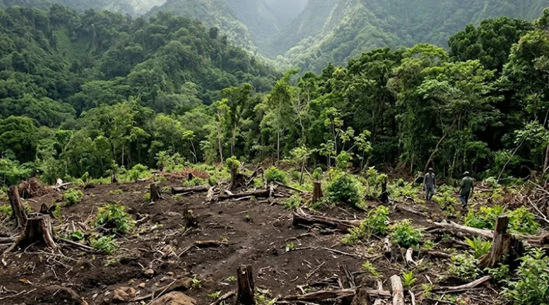
Consequences of Deforestation in a Volcanic Landscape
Deforestation in Dominica carries more severe physical consequences than in flatter terrains due to the island’s young volcanic geology and high rainfall, which trigger catastrophic landslides and rapid topsoil loss when stabilizing root systems are removed from the precarious, steep-sided mountain slopes.
Soil Erosion and Mass Wasting
Dominica’s soils, particularly the allophanic soils found in high-rainfall areas, are highly susceptible to erosion once the protective forest canopy and root systems are removed.
- Landslides: Deforested slopes are the primary sites of mass wasting. During heavy rainfall, the lack of root-binding capacity leads to debris flows that have historically resulted in loss of life and the destruction of entire villages (e.g., the Bagatelle landslide).
- Loss of Topsoil: Rapid runoff on cleared land strips away nutrient-rich topsoil, rendering the land unsuitable for agriculture within a few growing seasons and perpetuating a cycle of further forest clearance.
Watershed Degradation
Dominica’s reputation as the “Land of 365 Rivers” is dependent on the integrity of its watersheds.
- Siltation: Deforestation in the Layou River Watershed or the Roseau River Watershed leads to massive sediment loading in the rivers. This siltation clogs hydroelectric turbines operated by DOMLEC and increases DOWASCO‘s water treatment costs.
- Reduced Baseflow: Forests act as a sponge, regulating the release of water into streams. Deforested areas experience flashy hydrological behaviour, rapid flooding during rain, followed by significantly reduced water levels during dry spells.
Marine and Benthic Impact
The effects of terrestrial deforestation extend to the Caribbean Sea. Sediment plumes from deforested watersheds settle on the coral reefs of the Soufrière-Scotts Head Marine Reserve (SSMR) and the Cabrits National Park Marine Section. This sediment smothers coral polyps, leading to reef degradation and a decline in the artisanal fish populations that local communities rely on for food security.
The Legislative and Administrative Framework
The State manages and mitigates deforestation through a series of Acts and administrative divisions. Oversight is primarily vested in the Forestry, Wildlife and Parks Division.
Forestry and Wildlife Act
The Forestry and Wildlife Act (Chapter 60:02) is the primary legal instrument for forest protection.
- Prohibited Acts: It is an offense to cut, clear, or burn forest on Crown Lands without a permit from the Director of Forestry.
- Forest Reserves: The Act empowers the government to designate Forest Reserves where commercial activity is strictly prohibited or regulated to protect watersheds and biodiversity.
National Parks and Protected Areas Act
The National Parks and Protected Areas Act provides the highest level of protection for Dominica’s forests. It governs the Morne Trois Pitons National Park, Morne Diablotin National Park, and Cabrits National Park. Within these boundaries, deforestation for any purpose is strictly forbidden, and the ecosystems are preserved in their natural state for scientific and recreational use.
Physical Planning Act
The Physical Planning Act (2002) regulates changes in land use. Developers seeking to clear large tracts of forest for residential or commercial purposes must obtain Planning Permission. For significant projects, an Environmental Impact Assessment (EIA) is required to evaluate the potential for deforestation to cause landslides or watershed damage.
Data Analysis and Forest Trends
According to data synthesised from Global Forest Watch and the Food and Agriculture Organization (FAO), Dominica’s forest trends reflect the island’s vulnerability to climate shocks, as catastrophic hurricanes and shifting rainfall patterns increasingly disrupt natural regeneration and accelerate soil erosion in the steep volcanic interior.
| Period | Estimated Forest Cover Change | Primary Cause |
| 1990 – 2010 | Stable / Slight Gain | Natural regeneration following the decline of the banana industry. |
| 2015 (Tropical Storm Erika) | Localized Loss | Massive landslides and river scouring in specific valleys. |
| 2017 (H. Maria) | 85-90% Canopy Loss | Catastrophic wind damage and defoliation. |
| 2018 – 2030 | Ongoing Recovery | Rapid secondary growth and active reforestation by the Forestry Division. |
Carbon Sequestration
Dominica’s forests are critical carbon sinks. The National Biodiversity Strategy and Action Plan (NBSAP) identifies forest preservation as the primary mechanism for Dominica to maintain its status as a net-zero carbon emitter. The loss of primary rainforest is particularly damaging because the carbon stored in the old-growth biomass and soil is released into the atmosphere and takes centuries to re-accumulate.
Mitigation and Reforestation Initiatives
To combat the effects of deforestation, several national and international programs have been implemented within the Commonwealth of Dominica, focusing on intensive reforestation, community-led watershed protection, and the establishment of robust conservation corridors to protect the island’s unique biodiversity and vital topsoil.
The Morne Diablotin Reforestation Project
Following the damage of the 2010s, specific focus was placed on the slopes of Morne Diablotin. The goal is to replant fruit-bearing native trees, such as the Gommier and Wild Nutmeg, to restore the primary habitat for the Sisserou Parrot. This project utilises community forestry by involving local residents in the northern villages in sapling nurseries and planting.
Climate Resilience and Recovery Plan
Under the Climate Resilience and Recovery Plan CRRP, forest preservation is viewed as “Natural Infrastructure.” The plan aims for:
- Riparian Buffers: Establishing mandatory 30-meter non-clearance zones along all major rivers to prevent siltation.
- Slope Stabilization: Using bio-engineering,the strategic planting of deep-rooted trees—to secure road embankments instead of relying solely on concrete retaining walls.
The Role of CREAD
Building on the foundation laid by Climate Resilience Execution Agency for Dominica (CREAD), the Ministry of Environment, Rural Modernisation, Kalinago Upliftment and Constituency Empowerment now spearheads projects that integrate forest protection with economic development, promoting Eco-Agroforestry initiatives where farmers plant perennial fruit trees to maintain vital root structures and canopy cover on steep, erosion-prone terrain.
Future Outlook: Protecting the Nature Isle
The future of Dominica’s forests depends on the successful enforcement of the National Forest Policy (2022). This policy moves beyond simple protection and advocates for “Active Forest Management.”
- Invasive Species Monitoring: Following deforestation events, invasive species like the Giant African Snail and various non-native vines can choke out regenerating native saplings. Active management involves removing these threats to restore the primary rainforest.
- Sustainable Timber Industry: The Forestry Division explores ways to use fallen timber from storms (salvage logging) rather than felling live trees, providing a sustainable source of Mahogany and Gommier for the local furniture industry.
Dominica currently stands at a critical juncture, navigating the complex tension between essential modernisation and environmental preservation. The pursuit of transformative infrastructure developments, such as the new international airport project and the geothermal power plant, represents a bold leap toward economic independence and renewable energy. However, this progress must not come at the expense of the island’s verdant interior. Reflecting on our journey, it is clear that every acre of forest lost to development is a chip away at our national security. We are learning that true advancement is not measured solely by concrete and cables, but by our ability to weave these modern necessities into the existing tapestry of our rugged, emerald landscape without unravelling the very ecosystems that define us.
In this era of intensifying climate volatility, Dominica’s dense forests have transitioned from a beautiful backdrop to our most vital frontline defense. They serve as a living shield, anchoring the precarious volcanic soil against the torrential rains that characterise our tropical reality. To lose this canopy is to invite the physical degradation of our home, trading long-term stability for short-term gain.
As we look toward the future, our reflection must remain centred on the idea that resilience is found in balance. Protecting our forests is an act of survival; it ensures that as we build upward toward a more prosperous skyline, our roots remain deep enough to withstand the storms that are certain to come.


References
-
1.
Global Forest Resources Assessment Country Reports: Dominica 2005 https://www.fao.org/4/ai851E/ai851E00.pdf
-
2.
Forestry and Wildlife Act (1976) https://www.unodc.org/cld/uploads/res/document/forestry-and-wildlife-act_html/Forestry_and_Wildlife_Act.pdf
-
3.
Post-Hurricane David Recovery Study (1979) https://www.adaptation-undp.org/explore/latin-america-and-caribbean/dominica
-
4.
Global Forest Resources Assessment Country Reports: Dominica 2020 https://openknowledge.fao.org/server/api/core/bitstreams/cc161d98-6ab6-4383-9c76-d30c598d6201/content
-
5.
Dominica Forest Reference Level (FRL) Report 2024 https://redd.unfccc.int/media/2024-dom-zero-frel-report-jan-8-2024.pdf
-
6.
Dominica Forest Reference Level Forest Reference Emissions Level 2018-2025 https://redd.unfccc.int/media/2023dominica-modified-frel-report.pdf
-
7.
Forests For Us: Dominica Harnesses Nature for Climate Resilience and Economic Development https://www.worldbank.org/en/news/feature/2024/09/17/forests-for-us-dominica-harnesses-nature-for-climate-resilience-and-economic-development
-
8.
Morne Trois Pitons National Park https://worldheritageoutlook.iucn.org/explore-sites/morne-trois-pitons-national-park
-
9.
UNESCO Biosphere Reserve Proposal: Dominica - Country Profile https://www.cbd.int/countries/profile?country=dm
-
10.
Leveraging Eco-Tourism for Biodiversity Protection in Dominica (P170846) https://documents1.worldbank.org/curated/en/099121924145057652/pdf/P1708461bfaa4f0e01aae115dc50b7b5d4e.pdf