

Volcanic Peaks in Dominica
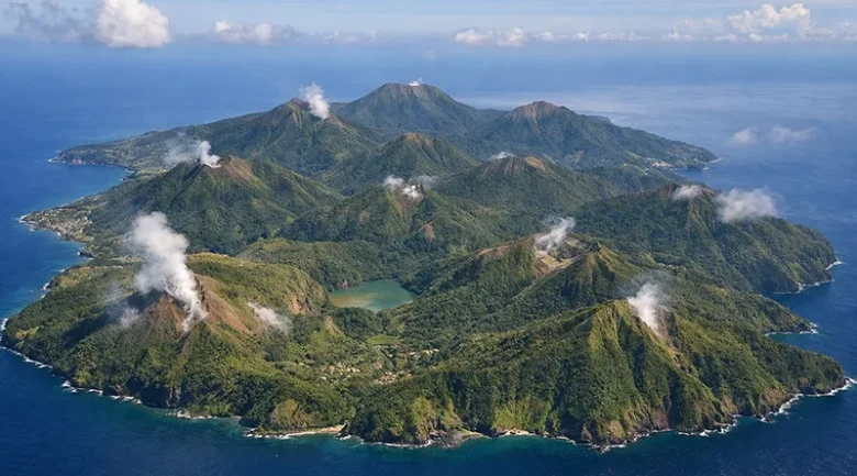
Dominica is often described as the most rugged island in the Caribbean, a direct result of being the most volcanically active territory in the region. While many neighbouring islands have one or two dormant peaks, Dominica is home to nine active volcanoes, the highest concentration in the world for an area of its size (approximately 290 square miles).
These peaks are not just geological hazards; they are the literal batteries of the island, providing the geothermal energy that powers the nation’s green industrial revolution.
The Big Three National Landmarks
The following peaks define the skyline of Dominica and are central to its UNESCO World Heritage status.
Morne Diablotin
Standing at 4,747 feet (1,447 meters), Morne Diablotins is the highest peak in Dominica and the second-highest in the Lesser Antilles.
- Character: It is a massive stratovolcano located in the north. Its slopes are covered in pristine primary rainforest, serving as the critical habitat for the endangered Sisserou Parrot (Dominica’s national bird).
- Experience: The hike to the summit is a gruelling, 6-hour vertical trek through elfin woodland, where the trees become stunted and moss-covered due to the altitude and moisture.
Morne Trois Pitons
The “Mountain of Three Peaks” is the centerpiece of the Morne Trois Pitons National Park.
- Geology: It features three distinct volcanic domes. This area is best known for its hydrothermal activity, home to the Boiling Lake and the Valley of Desolation.
- Status: This peak and its surrounding park were the first in the Eastern Caribbean to be listed as a UNESCO World Heritage site (1997).
Morne Watt
Located in the south-central region, Morne Watt (4,003 feet) is a significant volcanic center.
- Activity: It is closely associated with the geothermal vents of the Boiling Lake. The most recent phreatic (steam) explosion in Dominica occurred in the vicinity of Morne Watt in 1997, reminding the island of the active nature of its mountains.
The Southern Volcanic Complex
The south of Dominica is a cluster of younger, highly active volcanic domes that define the coastline and provide the heat for the Geothermal Power Plant in the village of Laudat.
- Morne Anglais: A perfectly conical peak overlooking the Roseau Valley. It is often the first big hike for locals due to its accessibility and breathtaking views of the capital.
- Morne Plat Pays: This volcano forms the massive caldera that holds the village of Soufrière. The southern edge of this volcano collapses into the sea at Scotts Head, creating the dramatic underwater drop-offs that make Dominica a world-class diving destination.
- Morne Nicholls: Often crossed by hikers on their way to the Boiling Lake, this peak offers a panoramic view of the steam rising from the Valley of Desolation.
Comparative Altitude Table
| Volcanic Peak | Altitude (ft) | Status | Primary Feature |
| Morne Diablotins | 4,747 | Active/Dormant | Sisserou Parrot Habitat |
| Morne Trois Pitons | 4,528 | Active | UNESCO World Heritage |
| Morne Watt | 4,003 | Active | Near Boiling Lake |
| Morne Anglais | 3,683 | Active | Roseau Valley Lookout |
| Morne Plat Pays | 3,110 | Active | Soufrière Bay Caldera |
Volcanic Hazards and Monitoring
Living among nine active volcanoes requires world-class science. As of 2026, the UWI Seismic Research Centre (SRC), in collaboration with the Office of Disaster Management (ODM), maintains a high-tech monitoring network across these peaks.
- Seismic Stations: Strategically placed on the flanks of Diablotins and Trois Pitons to detect microswarms of earthquakes that might indicate magma movement.
- Geochemical Sampling: Regular testing of gases (fumaroles) in the Valley of Desolation to monitor changes in carbon dioxide and sulfur levels.
- Geothermal Extraction: By tapping into the heat of the Wotten Waven/Laudat volcanic system, Dominica actually helps bleed off some of the hydrothermal pressure, converting potential volcanic risk into a stable source of renewable electricity.
The Nature Island Aesthetic
The volcanic peaks are the reason Dominica is the only Caribbean island that Christopher Columbus would still recognise today. Their steep, unforgiving terrain prevented the large-scale sugar plantation monocultures that levelled the forests of other islands.
Perspective: In Dominica, the mountains don’t just provide scenery, they provide the water (via 365 rivers), the soil (fertile volcanic ash), and the energy (geothermal) that define the nation’s future.


References
-
1.
Smithsonian Institution Global Volcanism Program - Dominica https://volcano.si.edu/volcanolist_countries.cfm?country=Dominica
-
2.
Volcanoes: Office of Disaster Management (ODM) https://odm.gov.dm/volcanoes-2/
-
3.
Volcanic Hazard Atlas of the Lesser Antilles https://uwiseismic.com/wp-content/uploads/2021/10/Dominica.pdf
-
4.
ResearchGate: The Volcanic Geology of Dominica https://www.researchgate.net/publication/269876122_The_Volcanic_Geology_of_the_Mid-Arc_Island_of_Dominica_Lesser_Antilles-The_Surface_Expression_of_an_Island-Arc_Batholith
-
5.
Public Seismic Network Inc. - Dominica's Volcanoes https://www.dpsninc.org/index.php/volcanoes
-
6.
UNESCO World Heritage Centre - Morne Trois Pitons https://whc.unesco.org/en/list/814/
-
7.
ThinkHazard! - Dominica Volcanic Risk Report https://thinkhazard.org/en/report/71-dominica/VA