
Salybia Constituency
The Salybia Constituency is one of the most distinctive electoral districts in Dominica. It encompasses the island’s only legally recognised Indigenous territory, the Kalinago Territory. Located along the east coast, this constituency is renowned for its cultural heritage, communal land governance, and scenic natural environment, making it an area of significant national and international interest.
Geographic and Community Overview of the Salybia Constituency
The Salybia Constituency is situated in the Saint David Parish on Dominica’s Atlantic-facing east coast.
The terrain is characterized by lush rainforests, river valleys, and coastal cliffs. Key communities within the constituency include Salybia, Gaulette River, Crayfish River, Bataka, Sineku, St. Cyr, Mahaut River, Concord and non-indegenous communities like Atkinson. The Kalinago Territory, formerly called the Carib Reserve, spans over 3,700 acres and is home to more than 3,000 people, making it the largest remaining Indigenous enclave in the Eastern Caribbean.
Geographic Boundaries:
- North: Bordered by the Atlantic Ocean, with coastal exposure stretching from Pagua Bay to the coastal cliffs at Pointe Gombo and Pointe Des Hertes.
- South: Shares internal land boundaries with the Castle Bruce Constituency, separated by ridges near Morne Fraser.
- West: Meets the Marigot Constituency at its eastern boundary within the Central Forest Reserve.
- East: The coastline of the Atlantic forms the eastern boundary, providing fishing access and influencing the marine biodiversity and livelihood practices of the constituency.
This region is characterized by winding river valleys such as the Gaulette River, Salybia River, and Mahaut River, and hilltop communities including Sineku, St. Cyr, and Concord. The terrain includes fertile slopes, forested areas, and cultural landmarks like Touna Kalinago Heritage Village, and the Kalinago Barana Autê.
Political Representation
Since Dominica’s independence in 1978, the Salybia Constituency has had a complex electoral history, often dominated by the Dominica Labour Party (DLP) and challenged by the United Workers Party (UWP). Below is a chronological summary of its elected representatives:
- Matthew Joseph (1980–1985, DDLP): Represented Salybia after the 1980 elections, focusing on education and infrastructure. Advocated for Kalinago rights and local services during a transformative political period.
- Ann Timothy (1985–1990, DFP): First woman to represent Salybia, contributing to national governance under the Freedom Party. Promoted healthcare access and emphasized women’s empowerment within Kalinago communities.
- Worrel Sanford (1990–1995, DLP): A community advocate, Sanford concentrated on agricultural assistance and representation of Kalinago issues in Parliament, ensuring stronger engagement in national debates during his tenure.
- Francois Barrie (1995–2000, UWP): Won Salybia amid a UWP surge, championing rural development and youth opportunities. Focused on improving constituency road access and expanding educational support.
- Kelly Graneau (2000–2009, DLP): Served nearly a decade, holding ministerial posts. Advocated for fisheries and agricultural programs while promoting Kalinago cultural identity in national development initiatives.
- Ashton Graneau (2009–2014, DLP): Defeated Sanford in a contested race. Served as Minister of Carib Affairs, strengthening Kalinago institutions, tourism, and community-based craft industries.
- Casius Darroux (2014–2019, DLP): Prioritized eco-tourism and cultural industries. Expanded local health and education facilities, encouraging youth entrepreneurship and greater economic independence for the Kalinago Territory.
- Cozier Frederick (2019–Present, DLP): Former lecturer and Kalinago Council member. Advocates for climate resilience, digital literacy, and housing development, embedding the Territory’s interests within wider national development policies.
These individuals have served as the elected representatives for the Salybia Constituency in the House of Assembly of Dominica. Their tenures reflect the political dynamics and shifts within the constituency over the decades.
Historical and Cultural Significance
The Salybia Constituency is the political cradle of Dominica’s Kalinago people, who trace their ancestral roots across the Eastern Caribbean. The area was formally set aside in 1903 as the Carib Reserve, later renamed the Kalinago Territory in 2015. The governance is shared between the Member of Parliament and the Kalinago Council, the elected Kalinago Chief chosen by the local community under the Kalinago Territory Act.
Natural features such as Isulukati Waterfall, L’Escalier Tête Chien, and the Kalinago Heritage Trail add to the eco-tourism potential of the area. The Waitukubuli National Trail: Segment #6 intersects this constituency, bringing hikers and researchers to explore its biodiversity and Indigenous legacy.
Development and Infrastructure
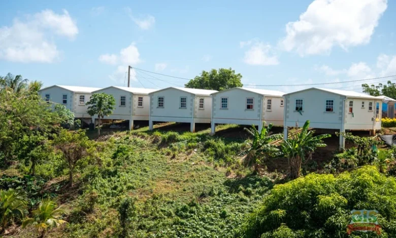
Major development projects in the constituency have included road realignments along the Concord-Salybia Road, climate-resilient housing initiatives through the Kalinago Resilient Housing Project, and community ICT programs under the Strengthening Community Resilience in the Kalinago Territory (SCR-K) initiative.
Essential public services in the area include:
- Salybia Health Centre and mobile clinics
- Salybia Police Station
- Sineku Primary School and Atkinson Primary School
- Kalinago Council Office
- Community Credit Unions and Artisanal Markets
- Cultural performance stages and youth centres
While internet connectivity and road access remain uneven in more remote areas, solar electrification and catchment water systems have been expanded under disaster-preparedness funding.