


Salisbury Constituency
The Salisbury Constituency lies along Dominica’s central west coast, encompassing coastal and hillside communities that reflect agricultural heritage and evolving political awareness. It includes the villages of Salisbury (Barroui), Coulibistrie, and Morne Rachette, each with distinct settlement patterns and infrastructural features. It contributes to national governance as a parliamentary constituency and remains a barometer of rural political sentiment.
Geographic Boundaries of the Salisbury Constituency
The Salisbury Constituency occupies a strategically coastal position on Dominica’s western flank, stretching from lowland beaches to interior ridges. Its legal boundaries are defined by intersecting lines with neighboring constituencies and natural geographic markers that anchor the territory both politically and physically.
- To the North-West, the constituency is bounded by the south-eastern limit of the Colihaut Constituency, demarcating the transition between the communities of Batalie and Colihaut. This point marks a shift from the Salisbury segment of the West Coast Road toward the northwestern coastline.
- To the North-East, it borders the south-western edge of the Marigot Constituency. This line runs through the interior and places the Salisbury boundary in proximity to northern highland ridges.
- To the South, the boundary extends from the intersection of the eastern border of the Saint Joseph Parish and the Pont Cassé-Hatton Garden Road at a location known as D’Leau Gommier. From there, it follows a straight line eastward to the southern source of the Macoucheri River, near Petit Macoucheri, enclosing a segment of the inland watershed.
- To the West, the constituency is naturally bounded by the Caribbean Sea, encompassing several stretches of coastal plain, beach access points, and active fishing zones.
This configuration positions the Salisbury Constituency as a coastal-to-inland electoral district with both marine and agricultural relevance. The boundaries not only reflect geographic separations but also shape electoral representation and development planning for the region.
Electoral Structure and Public Services
The Salisbury Constituency is part of Dominica’s 21-member parliamentary system and sends one elected Member of Parliament (MP) to the House of Assembly using the first-past-the-post system. As of the last reported roll, the constituency had just over 2,600 registered voters, divided across four polling districts.
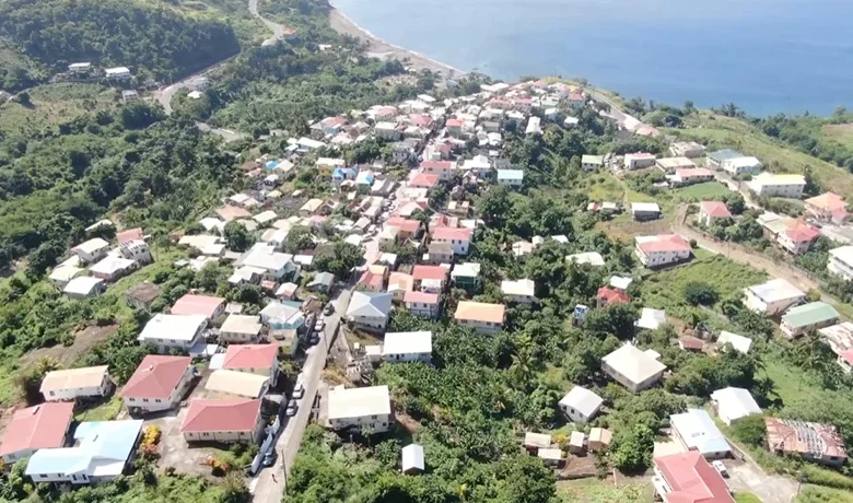
The coastal villages of Salisbury (Barroui), Coulibistrie, and Morne Rachette on Dominica’s west coast are served by an integrated network of essential public infrastructure and government-supported services. These facilities help anchor the daily lives of residents while enabling access to national systems of healthcare, education, and disaster preparedness.
Salisbury, the largest of the three communities, hosts the Salisbury Health Centre, which provides outpatient care, immunization services, and support for chronic conditions. The Salisbury Village Council manages local administration and coordinates with national agencies on development projects and emergency response. The village is also home to the Salisbury Police Station and the Salisbury Primary School, ensuring basic education and security. Public gatherings often take place at the Salisbury playing field, which doubles as a site for cultural events and weekly markets. One of the most historically significant features is the old banana port site, where produce was once exported, also the scene of the pivotal Salisbury Declaration in 1976.
Coulibistrie, located just north, contains vital community assets like the Coulibistrie Health Centre, which mirrors services offered in Salisbury. The Coulibistrie Police Station helps ensure security across both Coulibistrie and Morne Rachette. The Coulibistrie Primary School is an important educational hub for young residents. Infrastructure such as the Coulibistrie Bridge supports transit and trade along the Edward Oliver LeBlanc Highway, while the historic Coulibistrie Catholic Cemetery and adjacent church remain central to the village’s cultural identity. The Coulibistrie/Morne Rachette Village Council oversees disaster management and small infrastructure upgrades, particularly in storm-prone areas. Small-scale fishing and beach activity continue near the Coulibistrie River mouth and Batalie Beach.
Up in the hills, Morne Rachette shares governance with Coulibistrie and relies on its roads and ridgelines for transport and access. Though it lacks a dedicated clinic, residents utilize services in neighboring villages. The area saw infrastructure interventions after Tropical Storm Erika and Hurricane Maria, including temporary water storage tanks, hygiene stations, and cleanup support. The council has advocated for fire safety resources, including the installation of hydrants.
All three communities are connected by the island’s west coast highway and benefit from shared water supply systems, educational access, and community response plans that make them more resilient. Together, they represent a cohesive microregion balancing agricultural tradition with ongoing development needs.
Economic and Cultural Identity
Agriculture remains the economic backbone of the constituency. Banana cultivation, once the dominant industry, has declined due to reduced access to European markets and hurricane damage. However, farming pockets of root crop and vegetable continue, supported by programs through the Division of Agriculture and non-governmental groups.
Fishing is practiced along the Coulibistrie coast, with small-scale landings and local sales. Morne Rachette and upper Salisbury have also seen interest in guesthouse tourism and homestays, capitalizing on panoramic views and proximity to inland trails.
Culturally, the constituency is active in religious observance, hosting several churches and annual village feasts. Traditional music and drumming groups are present, and the villages often participate in national festivals and agricultural exhibitions.
Political Representation
Salisbury’s political history reflects the village’s transformation from party-affiliated loyalty to a growing emphasis on independent, community-centered leadership.
- 1980–1985: Dennison John – Dominica Freedom Party (DFP)
Elected during Dominica’s post-independence restructuring, John focused on stabilizing governance and strengthening rural ties through party-based democratic engagement. - 1985–1990: James Royer – Dominica Freedom Party (DFP)
Royer continued DFP’s platform, addressing agricultural needs and community development while reinforcing support for Dominica’s early democratic foundations. - 1990–2009: Earl M. Williams – United Workers Party (UWP)
Williams brought long-term representation, championing infrastructure and educational investment while rising to serve as Leader of the Opposition. - 2009–2019: Hector “Spags” John – United Workers Party (UWP)
A vocal critic of ruling policies, John emphasized protest politics, community organizing, and the preservation of agricultural livelihoods across Salisbury. - 2019–Present: Jesma Paul – Independent
Paul’s victory as an independent marked a shift toward grassroots representation focused on local empowerment, social support, and non-partisan leadership.
This evolution shows how Salisbury’s electorate has moved from party loyalty to issue-driven independence, responding to changing social and economic conditions over four decades.