


Fort Shirley
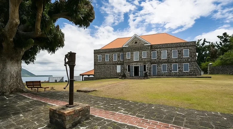
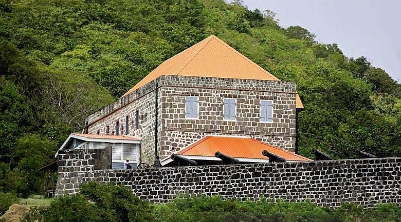
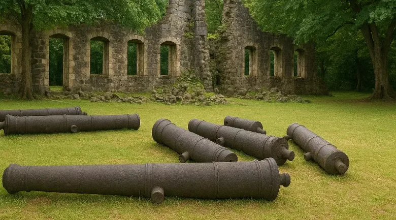
Fort Shirley remains a grand monument to 18th-century combat design and to the intricate, often tumultuous colonial eras of the Eastern Caribbean. Situated within the Cabrits National Park on a promontory overlooking the vast expanse of Prince Rupert Bay, this garrison was once the most formidable military installation in the British Leeward Islands. The site is not merely a collection of stone ruins; it is a profound narrative of imperial rivalry, the resilience of the African spirit during the 1802 mutiny, and the visionary restoration efforts that have transformed a forgotten jungle ruin into a premier heritage destination. Its location on the Cabrits, derived from the Spanish and Portuguese word for goats (cabras) left there by early mariners, provided a natural defensive advantage that made it the strategic pivot point for control over the northern waters of the Caribbean Sea.
The Strategic Value of Prince Rupert Bay
To understand the scale and investment poured into Fort Shirley, one must first recognise the geography of the northern leeward coast. Prince Rupert Bay is one of the deepest and most sheltered natural harbours in the region. Throughout the 1700s and 1800s, it served as a vital watering hole and refuge for the massive naval fleets of Britain, France, and Spain. The bay was named after Prince Rupert of the Rhine, a nephew of King Charles I, who visited the island in the 1650s. Because the bay could accommodate hundreds of ships simultaneously, protecting it became a matter of national security for the British Crown.
Construction began in earnest around 1765, shortly after the British acquired the island from the French following the Treaty of Paris. The design followed the Vauban-style principles of fortification, adapted for the rugged, volcanic terrain of the twin peaks of the Cabrits. For nearly a century, the fort was expanded and refined, eventually housing a garrison of over 600 men. It was designed to be entirely self-sufficient, featuring its own internal water systems, massive ordnance storage, and quarters for a hierarchical military structure reflecting the social stratifications of the British Empire.
The 1802 Mutiny: A Turning Point in British Military Law
One of the most significant events in the history of Fort Shirley, and indeed, the entire British Empire, occurred in April 1802. At the time, the garrison was partially manned by the 8th West India Regiment, a unit composed of enslaved Africans who were owned by the British Crown and trained as soldiers. The mutiny was sparked by rumours that the soldiers were to be disbanded and sent to work in the cane fields as plantation slaves, combined with the brutal leadership of their commanding officers and a dispute over pay.
For three days, the mutineers took control of the fort, capturing several officers and holding the Upper Battery. The uprising was eventually suppressed by the Royal Navy and other loyalist troops, but its impact was global. The bravery and tactical skill displayed by the African soldiers during the standoff forced the British Parliament to reconsider the legal status of slave-soldier units. In 1807, the Mutiny Act was amended to declare that all black soldiers in the British Army were free men from the moment of their enlistment. This makes Fort Shirley a hallowed ground for the history of abolition and the recognition of human rights in the Caribbean.
Key Structures and Defensive Features of the Garrison
The layout of Fort Shirley is a sophisticated network of batteries, domestic quarters, and logistical hubs. The architecture utilises local volcanic stone, lime mortar made from crushed coral, and imported English brick.
- The Great Battery: Positioned to face the entrance of Prince Rupert Bay, this massive platform once held 24-pounder cannons capable of sinking any hostile vessel attempting to anchor in the harbour.
- The Upper Battery: Located on the higher slopes, it provided a secondary line of defence and a vantage point to fire down upon attackers who might have breached the lower walls.
- The Powder Magazine: A heavily reinforced, vaulted structure designed to be bomb-proof, keeping the garrison’s gunpowder dry and safe from incoming artillery fire.
- The Officers’ Quarters: Now one of the most beautifully restored buildings on the site, it features wide verandas designed to catch the sea breeze, reflecting the British attempt to adapt to the tropical climate.
- The Soldiers’ Barracks: Large, austere halls that once housed hundreds of men in cramped conditions, where disease, particularly yellow fever, often claimed more lives than combat.
- The Guard House and Dungeon: Located near the main gate, this served as the administrative centre and the site for military discipline.
- The Cisterns: Sophisticated rainwater harvesting systems that were vital for survival, as there are no natural springs on the Cabrits peninsula.
- The Bakehouse and Kitchens: Remnants of the logistical tail required to feed a 600-man garrison in a remote colonial outpost.
Decline, Abandonment, and the Jungle’s Reclamation
Following the end of the Napoleonic Wars and the mid-19th-century shift in naval technology from sail to steam, Fort Shirley’s strategic importance began to wane. The British military officially abandoned the post in 1854. For the next century, the site was surrendered to the forces of nature. Tropical vines, banyan trees, and dense scrub encroached, cracking the stonework and concealing the batteries from view.
For much of the 20th century, the fort existed primarily in the memory of local residents and as a site for occasional “liming” or exploration by adventurous hikers. The massive cannons were toppled from their carriages, and the wooden roofs of the quarters rotted away, leaving only the skeletal stone walls as a reminder of the site’s former glory. It was during this period of neglect that the fort gained a haunting, romantic aura, often described by early travellers as a Caribbean Angkor Wat.
The Restoration Era and Dr. Lennox Honychurch
As a distinguished Dominican historian, anthropologist, and artist, Dr. Lennox Honychurch remains inseparably linked to the successful modern revival of Fort Shirley. Beginning in the 1980s, Honychurch spearheaded a Herculean effort to clear the jungle and restore the structures using traditional methods and materials. Unlike many restoration projects that rely on modern concrete, the work at Fort Shirley has prioritised historical accuracy, utilising local lime-burning techniques to create mortar that matches the original 18th-century composition.
Today, the fort serves as a cultural hub and the headquarters of the Cabrits National Park. The restored Officers’ Quarters frequently hosts weddings, international conferences, and concerts, demonstrating that historic sites can remain economically viable and socially relevant. The restoration is an ongoing process, with each decade bringing new life to different sections of the sprawling complex.
Historical Milestones of the Cabrits Peninsula
The timeline of the fort reflects the broader geopolitical shifts for over four centuries.
- 1500s–1600s: Early Spanish and French mariners used the Cabrits as a landmark and a source of fresh water from nearby springs.
- 1763: Britain takes formal control of the island; the strategic value of the northern bay is recognised.
- 1765: Formal construction of the defensive works at the Cabrits begins under the name Fort Shirley, honouring Sir Thomas Shirley.
- 1778–1784: The French briefly retake the island and continue work on the fortifications, leaving a French architectural influence on certain gatehouses.
- 1802: The mutiny of the 8th West India Regiment occurs, leading to a permanent change in the status of black soldiers in the British Army.
- 1805: The fort serves as a vital refuge during the French invasion of the island led by General La Grange; the British governor, George Prevost, retreats to the Cabrits to hold out against the French.
- 1854: The garrison is officially decommissioned as the British consolidate their Caribbean forces.
- 1982: The Cabrits National Park is officially established, protecting both the terrestrial ruins and the surrounding marine environment.
- 1980s–Present: Ongoing restoration efforts have transformed the site into a major educational and tourism asset.
The Modern Experience: Tourism and Ecology
In the current era, Fort Shirley is a primary destination for travellers seeking to connect with the Nature Island beyond its waterfalls and rainforests. The walk from the park entrance to the fort takes visitors through a unique dry-coastal forest ecosystem, home to hermit crabs, migratory birds, and the ubiquitous ground lizards. The view from the Great Battery remains one of the most photographed vistas in the Caribbean, offering a 270-degree panorama of the town of Portsmouth, the purple-hued hills of the north, and the distant islands of the French West Indies.
The site is also a candidate for UNESCO World Heritage status, recognised for its exceptional preservation and its role in the global history of the African diaspora. For the local community in Portsmouth, the fort is a source of immense pride, a symbol of a past navigated with courage and a future built on the foundation of heritage preservation and sustainable tourism.


References
-
1.
Commonwealth of Dominica: Fort Shirley / Cabrits National Park https://oecs.int/en/component/spproperty/property/56-fort-shirley?Itemid=286
-
2.
The French and Dominica, 1699-1763. Jamaican Historical Review https://search.proquest.com/openview/b24daaa95bafacf08f43b34f2760a16f/1?pq-origsite=gscholar&cbl=1817015
-
3.
Alternative to mass tourism in Dominica. Annals of Tourism Research https://www.sciencedirect.com/science/article/abs/pii/016073839190049H
-
4.
Emancipation, Independence and the Resurrection of Dominica’s Fort Shirley https://dominicanewsonline.com/news/homepage/news/emancipation-independence-resurrection-dominicas-fort-shirley/
-
5.
Fort Shirley https://whc.unesco.org/en/tentativelists/6020/