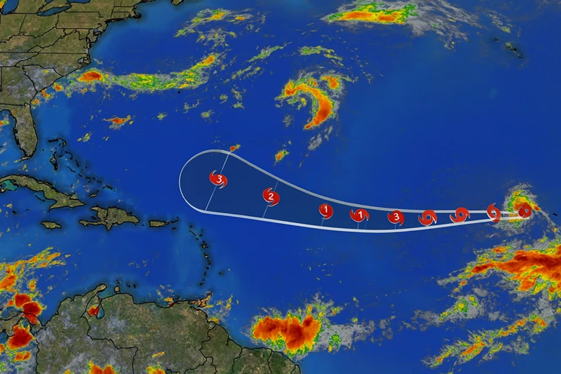
Tropical Storm Erin Tracking Toward Lesser Antilles

The 2025 Atlantic hurricane season has recorded its fifth named storm with the formation of Tropical Storm Erin in the eastern Atlantic. Meteorologists are closely monitoring its progress as forecasts indicate it could strengthen into the season’s first hurricane.
Erin formed from a tropical wave that moved off the African coast earlier this week. The National Hurricane Center reported maximum sustained winds of 40 miles per hour as of the latest advisory, with further intensification expected over the next few days as it tracks westward across warm Atlantic waters.
Current projections place the storm on a path toward the Lesser Antilles by the weekend. While forecasters caution that the track could shift, residents in the Eastern Caribbean, including Dominica, are being advised to monitor updates and review preparedness plans.
Meteorological officials have noted that Erin’s development underscores the heightened activity anticipated for the 2025 season, which has already produced several early-season systems. Should the storm continue to strengthen, it may reach hurricane status before nearing the islands.
Emergency management agencies in Dominica are urging communities to remain vigilant. Standard advice includes checking household emergency supplies, securing property, and ensuring access to official weather alerts.
The 2025 season runs until November 30, with conditions in the Atlantic currently favorable for tropical cyclone formation. Erin’s progression over the coming days will determine the level of impact on the Caribbean.
If necessary, watches and warnings will be issued in the coming days for territories in the storm’s projected path.
This article is copyright © 2025 DOM767


